Severe storm complex is rapidly advancing toward the Tulsa metro area with forecasts warning of damaging winds, very heavy rain, and the potential for a dangerous spin-up tornado. As of 10:15 PM, radar shows intense storm activity pushing eastward from communities including Enid, Stillwater, and Pawnee, heading directly toward Tulsa and surrounding suburbs.
Severe Weather Threat Escalates for Tulsa Tonight
Forecasters confirm that the storm system currently sweeping through Oklahoma is producing damaging winds capable of uprooting trees, knocking down power lines, and causing structural damage throughout the Tulsa metropolitan area. Intense rainfall within the storm is already triggering rapid water accumulation, putting low-lying roads and neighborhoods at risk for flooding.
Although less common, meteorologists stress that a spin-up tornado remains a serious possibility within the storm complex. The National Weather Service advises all residents in and near Tulsa to seek shelter immediately and remain indoors in a sturdy, interior location on the lowest floor until the threat passes.
Storm Path and Impact Zone
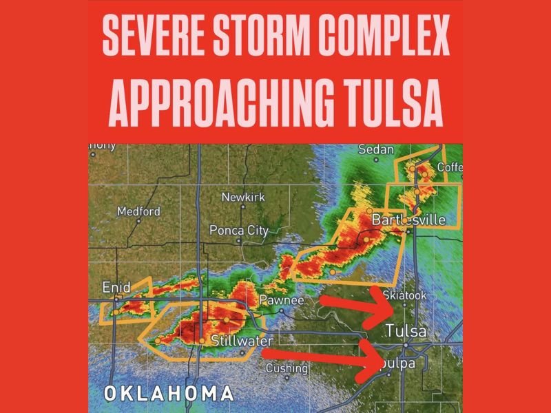
At 10:15 PM, the severe storm complex extends in a corridor from near Enid eastward through Pawnee and Skiatook toward Tulsa. Radar highlights two dominant warning polygons targeting separate storm cells aimed directly at the metro area. One storm line moves straight toward Tulsa, while a second tracks toward Sapulpa, just south of the city. Meanwhile, northern communities such as Bartlesville and Washington County remain under active warning as another cell pushes through the area.
Earlier in the evening, Severe weather has already impacted Stillwater, Pawnee, and Cushing, with reports of damaging wind gusts and heavy rainfall making travel hazardous. The storm continues its eastward march and is expected to bring increasingly severe conditions into Tulsa within the next couple of hours.
Immediate Safety Actions for Tulsa Residents
Authorities urge everyone in Tulsa and surrounding suburbs including Skiatook and Sapulpa to move to interior shelter without delay. Stay away from windows, avoid driving through flooded areas, and maintain constant access to weather updates via local broadcasts or trusted emergency alert systems.
“Seek interior shelter on the lowest floor of a sturdy building immediately and avoid waiting for the storm to arrive,” advised forecasters monitoring the threat.
This storm event is unfolding right now and poses a significant hazard to life and property across northeastern Oklahoma. With damaging winds forecasted to produce widespread impacts and the tornado threat remaining active, the need for urgent preparedness has never been higher.
Why This Matters Beyond Oklahoma
Severe storm outbreaks like this one underscore ongoing risks faced not only in Oklahoma but across the central and southern Plains states, including Colorado’s eastern front. Rapidly shifting weather patterns this spring have heightened the chances of damaging winds, flash flooding, and tornado formation throughout the region. Residents in Colorado and beyond should remain vigilant during these volatile weather periods and heed all local warnings.
Stay tuned to The Colorado Daily for the latest updates on this developing severe weather system and its broader impact on the Plains and Rockies corridors.