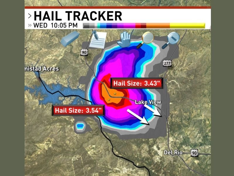
DEL RIO, TX — A violent supercell thunderstorm capable of producing giant hailstones measuring up to 3.54 inches in diameter was confirmed over Lake Amistad at 10:05 PM Wednesday, sending shockwaves through the region as it advanced southeast toward heavily populated areas including Del Rio, Lake View, and Amistad Acres.
This storm is part of an intense, ongoing severe weather event sweeping across southern Texas and represents one of the largest hail events recorded so far. Radar analysis and Hail Tracker data captured two distinct giant hail cores inside the supercell, verifying stones measured at 3.54 inches and 3.43 inches, respectively—classified as catastrophic hail capable of severe destruction.
Giant Hail Core Centered Directly Over Lake Amistad
At the time of observation, the storm’s most intense hail cluster was concentrated over Lake Amistad. Hail Tracker imagery showed deep red and magenta returns over the lake, indicating the storm’s updraft was generating the largest hailstones within the supercell’s core. Such hail sizes are notorious for shredding vehicle roofs, smashing windows, and ripping through residential and commercial roofing materials.
The threat extends beyond property – these giant hailstones pose a life-threatening risk for anyone caught outside. Emergency officials are urging residents in the storm’s path to seek immediate shelter as the storm moves rapidly southeast.
Supercell Moves Southeast, Threatening Del Rio and Surrounding Communities
The destructive hail core is tracking southeast, aligning directly with Del Rio’s urban corridor, as well as smaller neighboring communities of Lake View and Amistad Acres. This path places these populated areas in high jeopardy of receiving significant hail damage in the next critical hours.
Hail swaths on radar present a broad field of smaller, yet still damaging hail sizes spreading well beyond the core zone, increasing the impacted footprint over a wide geographic area surrounding the lake.
Multiple Supercells Delivering Back-to-Back Giant Hail Threat
Meteorologists confirm this storm strikes amid a series of supercells already hammering the region. At least one earlier giant hail-producing supercell swept the same corridor before the lake storm formed, compounding the overall damage and risk across southwest Texas.
The frequency of these intense storms highlights an extraordinarily active severe weather night for communities stretching through Del Rio and Lake Amistad, prompting high alert status for local emergency services.
What’s Next: Continued Monitoring and Warnings
Officials and storm trackers continue to monitor the storm’s southeast progression closely. Residents in southeastern Texas tornado- and hail-prone areas are urged to stay updated through local alerts and avoid outdoor exposure during the storm’s peak activity.
For ongoing, detailed coverage of this severe weather outbreak and expert storm analysis across the United States, follow updates at SaludaStandard-Sentinel.com.
“Giant hail falling at this size is an unprecedented danger to lives and property — seek shelter immediately,” stated a regional meteorologist tracking the event.
This severe storm event underlines the volatile and dangerous nature of this week’s weather system affecting the southern US, reinforcing the need for vigilance and rapid response from communities at risk.