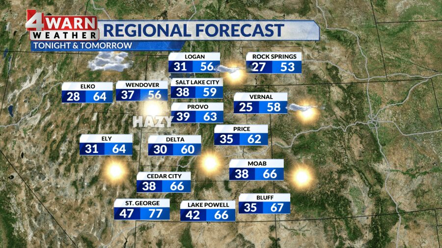
UPDATE: Hazy sunshine and warming temperatures are sweeping across Utah today, with daytime highs expected to reach the upper 50s to low 60s. As a ridge of high pressure settles in, residents can anticipate a significant shift from the chilly start of the week.
After a week marked by cold temperatures, the Wasatch Front will see highs climbing to around 60°F this afternoon, while St. George could soar into the low 70s. However, beware: a lingering haze is set to affect air quality across the region.
Officials from the Department of Air Quality have issued a warning for “moderate air” quality in Davis, Salt Lake, and Utah counties, with increased particulate matter expected due to a shallow inversion. This weather phenomenon traps pollutants close to the ground, leading to a noticeable haze in the valleys.
As inversion season kicks off, residents are reminded of the geographical challenges that exacerbate air quality issues in Utah. The unique mountain terrain restricts air mixing, prolonging haze conditions.
Looking ahead, Halloween promises clear skies and dry conditions, making it ideal for trick-or-treaters. Temperatures will hover around 60°F along the Wasatch Front and reach the upper 70s in Washington County.
As evening approaches, temperatures are predicted to drop from the 70s to the 60s in southern Utah, while northern Utah will see a decrease from the 50s into the 40s.
November is expected to kick off with similar conditions, sustaining above-average warmth and dry skies. Additionally, don’t forget that Daylight Saving Time ends this weekend. Set your clocks back one hour before bed on Saturday night, as the official transition occurs at 2 AM on November 5, 2023.
Stay tuned for the latest updates on weather developments from our 4Warn Weather forecast team. We’re committed to keeping you informed about what matters most in Utah!