A collaborative research team from Fudan University, the University of Twente, and Chengdu University of Information Technology has developed an innovative algorithm to enhance the monitoring of soil freeze-thaw (FT) transitions from space. Published on September 10, 2025, in the Journal of Remote Sensing, this study addresses the challenges faced in accurately capturing these critical processes that influence weather patterns and hydrological cycles.
Soil freeze-thaw cycles significantly affect surface albedo, moisture, and heat fluxes. However, traditional large-scale models often overlook diurnal soil temperature variations and surface heterogeneity, leading to inaccuracies in monitoring. The team identified that existing algorithms, particularly those based on the Soil Moisture Active Passive (SMAP) satellite data, relied on globally fixed parameters that frequently failed under diverse land cover and climatic conditions.
To tackle these limitations, researchers created a dynamic parameter optimization framework specifically for soil FT retrieval. This new algorithm improves the existing Diurnal Amplitude Variation-based Freeze-Thaw (DAV-FT) algorithm by introducing three key parameters: α, β, and γ. These parameters represent the detection period, variance window, and threshold sensitivity, respectively. By employing a method similar to maximum likelihood estimation, the team tuned these parameters to maximize overall classification accuracy across various regions.
Improved Detection and Accuracy
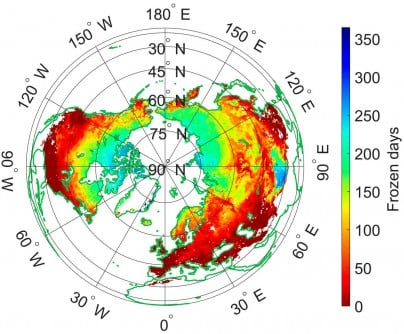
The optimized algorithm distinguishes between freezing and thawing states by analyzing annual variations in L-band brightness temperature observed by the SMAP satellite. The results are promising, showing that areas with an overall accuracy (OA) greater than 0.7 increased significantly from 54.43% to 89.36%. The most robust performance was noted in the Qinghai–Tibet Plateau, southwestern Eurasia, and southern North America.
Validation of the new model demonstrated high correlations with existing datasets, achieving an accuracy of 81.28% with the ERA5-Land dataset and 79.54% with the SMAP-FT dataset. Validation using data from 828 in situ soil temperature stations confirmed the algorithm’s superior accuracy and stability, with a median accuracy of 0.92, surpassing both fixed-parameter models and current SMAP products.
Dr. Shaoning Lv, the study’s corresponding author, emphasized the significance of the dynamic parameter optimization. “This advancement greatly enhances our ability to capture subtle soil freeze-thaw transitions that vary across regions and seasons,” he stated. By reflecting diurnal surface changes in real time, the method not only refines the retrieval accuracy of L-band data but also fosters a deeper understanding of land-atmosphere interactions.
Implications for Climate Monitoring
The improved DAV-FT algorithm establishes a robust framework for continuous monitoring of soil freeze-thaw dynamics across diverse terrains. This development is particularly valuable for climate modeling, agricultural management, and hydrological forecasting. Its ability to accommodate diurnal temperature cycles and regional heterogeneity makes it especially effective in high-latitude and mountainous regions, where existing algorithms often struggle.
By enhancing the accuracy of soil state detection from space, this innovative method strengthens the foundation for assessing permafrost dynamics, water availability, and land-atmosphere energy fluxes. These factors are crucial in predicting climate change impacts and improving global land-surface models.
The research received funding from the National Key R&D Program of China (grant no. 2022YFF0801404), the Key Research and Development and Achievement Transformation Program of Inner Mongolia Autonomous Region (grant no. 2025YFDZ0007), the Yan Liyuan–ENSKY Foundation Project of the Zhuhai Fudan Innovation Research Institute (grant no. JX240002), and the National Natural Science Foundation of China (grant no. 42075150).
Overall, this research represents a significant step toward advancing global-scale climate monitoring with enhanced temporal and spatial precision. The implications for environmental science and policy could be profound, as improved soil monitoring contributes to more accurate climate predictions and better management of natural resources.